Welcome to your first lesson on the path to becoming a geographer. Consider that much of geography is viewed from a spatial perspective. Everything from climate to populations is viewed in terms of where they are located, to whom or what they are near, and how their location influences and is influenced by other characteristics near that location.

Since you will be using maps and globes throughout this course, you will need to have a solid understanding of how to use the basic tools for indicating world locations with certainty. Geographers use latitude and longitude to measure distances on Earth and create a global grid that allows for very absolute descriptions of locations on the globe.
Lines of latitude run parallel to the equator (0°) and measure distance north or south of the equator. Each line of latitude is a circle around Earth. The equator is the largest circle, and the poles (90° N and 90° S) are actually points as the circle closes in upon itself. When describing location, if you were to use latitude alone, you would be describing any one of a number of points along that line. For example, if you told a friend that your house was located at 60° S latitude, you could be describing any of the locations noted by the dots on the 60th parallel south of the equator.

Meridians, or lines of longitude, run from one pole to the other. They are not parallel, as they meet at the poles. Lines of longitude measure distance east or west of the prime meridian (0°).
Since the equator is a circle, it can be divided into 360°. That means there are 360 lines of longitude. There are 180 of them that measure distance west of the prime meridian and 180 of them that measure distance east of the prime meridian. (On the globe at the left, you can only see 90° E or W. That is due to the fact that we can see only one-half of a globe at any one time.) Longitude works the same way as latitude. When describing location, if you were to use only longitude, you would be describing any one of a number of points along that line. For example, if you told your parents that summer camp was located at 60° W longitude, you could be describing any of the locations noted by the dots on the 60th meridian west of the prime meridian.
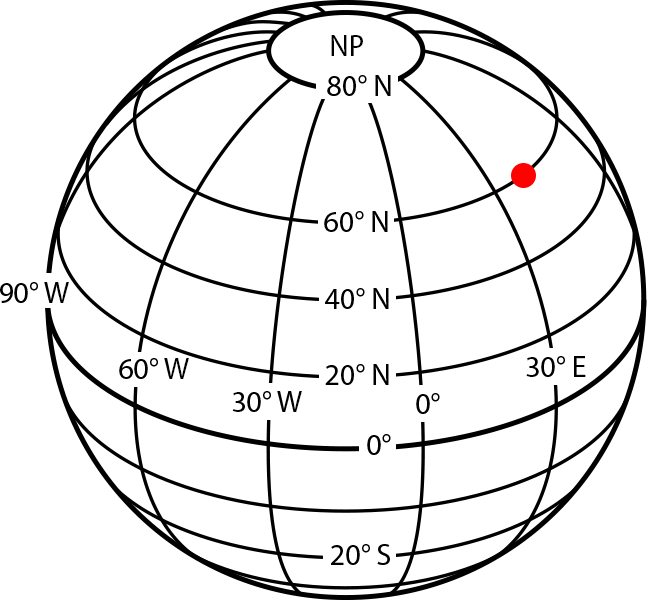
Since longitude and latitude used alone can only limit your search to any point along a line, you have to use them together. Lines of latitude and longitude cross one another to form a global grid. Using a measurement for each will bring you to a very specific point called an absolute location. On the globe shown to the left, the coordinates of 60° N and 35° E pinpoint an absolute location represented by a single dot.
Once you understand which line measures what distance, you can use longitude and latitude to give very specific and accurate descriptions of where places, things, or people are located on Earth. There is only one problem. These lines are imaginary! If you take a look outside, you won’t see a grid pattern painted carefully on Earth to assist you with navigation. That means you have to have a way to calculate or find that information on your own.