Grid Coordinate System
How is the grid coordinate system used?
Goal:
Goal:
By Strebe - Own work, CC BY-SA 3.0, Link
The grid coordinate system uses grid lines to define coordinate locations so that coordinate points can be plotted accurately on a map.
If you look at this simple grid coordinate system, you can see the equator at 0° latitude and the prime meridian (or Greenwich) at 0° longitude. From there, each grid line is equally spaced, depending on the degrees latitude or longitude.
Lines of latitude measure 0-90° north and south.
Lines of longitude measure 0-180° east and west.
| When you plot coordinate points on a grid coordinate system, you start with the latitude lines, which will measure either N (north) or S (south). | |
|---|---|
| If it is north,... | go UP. ⇧ |
| If it is south,... | go DOWN. ⇩ |
| Longitude lines are plotted next, and they will measure either E (east) or W (west). | |
| If it is east,... | go RIGHT. ⇨ |
| If it is west,... | go LEFT. ⇦ |
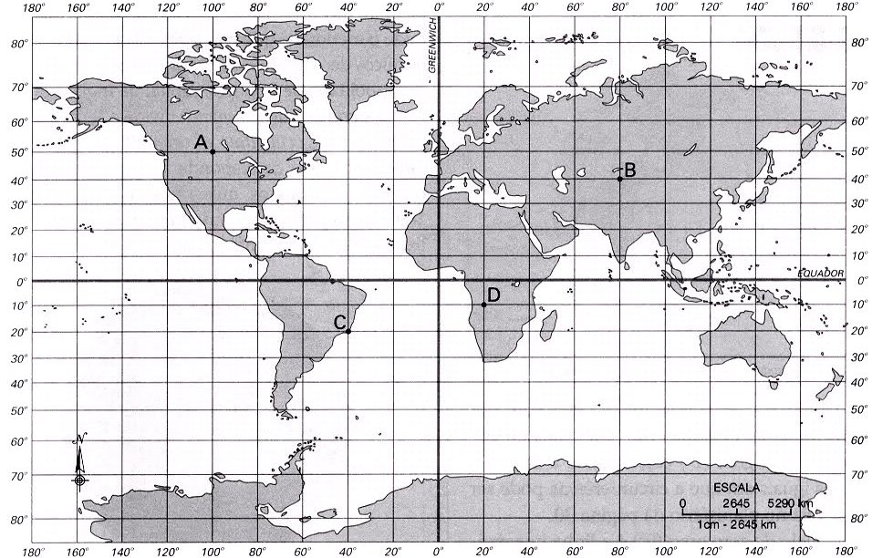
Practice plotting coordinates.
Use the map below to click and drag the coordinates to the letter at that location on the map.
|
50° N, 100° W
40° N, 80° E
10° S, 20° E
20° S, 40° W
|
Wow, great job!
You got all of them right!
Whoops. Something is not quite right.
Change any answers with X's and try again.